

-
Friday, March 13, 2009
Thursday, March 12, 2009
Wednesday, March 11, 2009
Terrestrial Impact Craters : Kara-Kul, Tajikistan
Kara-Kul, Tajikistan
Target Name: Earth
Spacecraft: Space Shuttle
Produced by: NASA
Copyright: Copyright Free
Related Documents
* Terrestrial Impact Craters
* Earth From Space
* Frozen Kara-Kul Structure, Tajikistan
Download Options
Name Type Width x Height Size
karakul.jpg JPEG 640 x 423 45K
karakul.jpg JPEG 1516 x 1002 168K
karakul.jpg JPEG 3032 x 2004 854K
Location 38°57'N, 73°24'E
Rim diameter 45 kilometers (28 miles)
Age <10 million years
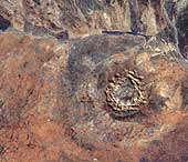
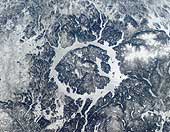
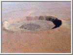
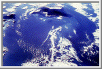
This picture shows the spectacular Kara-Kul structure. Partly filled by the 25-kilometer (16-mile) diameter Kara-Kul Lake, it is located at 3,900 meters (12,900 feet) above sea level in the Pamir Mountain Range near the Afghan border. Only recently have impact shock features been found in local breccias and cataclastic rocks.
Target Name: Earth
Spacecraft: Space Shuttle
Produced by: NASA
Copyright: Copyright Free
Related Documents
* Terrestrial Impact Craters
* Earth From Space
* Frozen Kara-Kul Structure, Tajikistan
Download Options
Name Type Width x Height Size
karakul.jpg JPEG 640 x 423 45K
karakul.jpg JPEG 1516 x 1002 168K
karakul.jpg JPEG 3032 x 2004 854K
Location 38°57'N, 73°24'E
Rim diameter 45 kilometers (28 miles)
Age <10 million years
This picture shows the spectacular Kara-Kul structure. Partly filled by the 25-kilometer (16-mile) diameter Kara-Kul Lake, it is located at 3,900 meters (12,900 feet) above sea level in the Pamir Mountain Range near the Afghan border. Only recently have impact shock features been found in local breccias and cataclastic rocks.
Terrestrial Impact Craters : Gosses Bluff, Northern Territory, Australia
 Gosses Bluff, Northern Territory, Australia
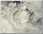
 23°50'S, 132°19'E; rim diameter: 24 kilometers; age: 142.5 +- 0.5 million years 142 million years ago, an asteroid or comet slammed into what is now the Missionary Plains in Australia's Northern Territory, forming a crater 24 kilometers in diameter and 5 kilometers deep. Today, like a bull's eye, the circular ring of hills that defines Gosses Bluff stands as a stark reminder of the event. The crater is located just south of MacDonnel Ranges (top of the picture). It is highly eroded. The circular ring of hills (5 kilometers or 3 miles diameter) is actually the results from differential erosion of the central uplift within this large complex crater. The crater rim is eroded to the point that it is no longer visible though it is probably located along the grayish colored drainage system outside the inner ring. (Courtesy USGS)
Terrestrial Impact Craters : Bosumtwi, Ghana
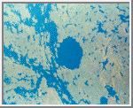
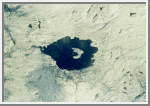
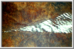
 Bosumtwi, Ghana 06°32'N, 01°25'W; rim diameter: 10.5 kilometers (6.5 miles); age: 1.3 +- 0.2 million years This crater is situated in crystalline bedrocks of the West African Shield and is filled almost entirely by Lake Bosumtwi. Chemical, isotopic, and age studies demonstrate that the crater is the most probable source for the Ivory Coast tektites, which are found on land in the Ivory Coast region of central Africa and as microtektites in nearby ocean sediments. In this photo the crater lake is partly obscured by clouds. (Courtesy NASA/LPI)
Terrestrial Impact Craters : Deep Bay, Saskatchewan, Canada
 Deep Bay, Saskatchewan, Canada 56°24'N, 102°59'W; rim diameter: 13 kilometers (8 miles); age: 100 +- 50 million years This crater consists of a near-circular bay, about 5 kilometers (3 miles) wide and 220 meters (720 feet) deep, in the otherwise shallow Reindeer Lake. Such deep circular lakes are unusual in this region, which is dominated by the shallow gouging of glacial erosion. The circular shoreline, at a diameter of 11 kilometers (6.8 miles), is partially surrounded by a ridge with heights to 100 meters (328 feet) above the lake surface. The diameter of this ridge, ~13 kilometers (8 miles), is likely the outer rim of the impact structure. The structure was formed in Precambrian metamorphic crystalline rocks with a conspicuous northwest trending fabric. Although not obvious from the surface, Deep Bay is a complex impact structure with a low, totally submerged central uplift. Samples obtained in the 1960's from drilling into the central structure revealed shocked and fractured metamorphic rocks flanked by deposits of allocthonous, mixed breccias. (Courtesy NASA/LPI)
Terrestrial Impact Craters : Clearwater Lakes, Quebec, Canada
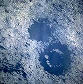 Clearwater Lakes, Quebec, Canada Clearwater Lake West: 56°13'N, 74°30'W; rim diameter: 32 kilometers (20 miles) Clearwater Lake East: 56°05'N, 74°07'W; rim diameter: 22 kilometers (13.7 miles) age: 290 +- 20 million years These twin circular lakes (large dark features) were formed simultaneously by the impact of an asteroidal pair which slammed into the planet approximately 290 million years ago. The lakes are located near the eastern shore of Hudson Bay within the Canadian Shield in a region of generally low relief in northern Quebec province. Notice that the larger western structure contains a ring of islands with a diameter of about 10 kilometers that surrounds the center of the impact zone. They constitute a central uplifted area and are covered with impact melts. The central peak of the smaller Clearwater Lake East is submerged. The lakes are named after their exceedingly clear water. Also notice that the surrounding terrain shows widespread scarring from glaciation. The multitude of linear and irregular shaped lakes (dark features) are the result of gouging or scouring action caused by the continental ice sheets that once moved across this area. (Courtesy NASA)
Terrestrial Impact Craters : Manicouagan, Quebec, Canada
 Manicouagan, Quebec, Canada 51°23'N, 68°42'W; rim diameter: ~100 kilometers (62 miles); age: 212 +- 1 million years The Manicouagan impact structure is one of the largest impact craters still preserved on the surface of the Earth. This shuttle view shows the prominent 70 kilometers (43 miles) diameter, ice-covered annular lake that fills a ring where impact-brecciated rock has been eroded by glaciation. The lake surrounds the more erosion-resistant melt sheet created by impact into metamorphic and igneous rock types. Shock metamorphic effects are abundant in the target rocks of the crater floor. Although the original rim has been removed, the distribution of shock metamorphic effects and morphological comparisons with other impact structures indicates an original rim diameter of approximately 100 kilometers (62 miles). (Courtesy NASA/LPI)
 Terrestrial Impact Craters : Mistastin Lake, Newfoundland and Labrador, Canada
 Mistastin Lake, Newfoundland and Labrador, Canada 55°53'N, 63°18'W; rim diameter: 28 kilometers (17.4 miles); age: 38 +- 4 million years This shuttle image shows a winter view of the Mistastin Crater, a heavily eroded complex structure. Eastward moving glaciers have drastically reduced the surface expression of this structure, removing most of the impact melt sheet and breccias and exposing the crater floor. Glacial erosion has also imparted an eastward elongation to the crater that is particularly evident in the shape of the lake that occupies the central 10 kilometers (6 miles) of the structure. Horseshoe Island, in the center of the lake, is part of the central uplift and contains shocked Precambrian crystalline target rocks. Just beyond the margins of the lake are vestiges of the impact melt sheet that contains evidence of meteoritic features in quartz, feldspar and diaplectic glasses. (Courtesy NASA/LPI)
Terrestrial Impact Craters : Roter Kamm, South West Africa/Namibia
 Roter Kamm, South West Africa/Namibia 27°46'S, 16°18'E; rim diameter: 2.5 kilometers (1.55 miles); age: 5 +- 0.3 million years Located in the Namibia Desert, the raised crater rim is clearly visible against darker background vegetation. Target rocks include primarily Precambrian crystalline rocks and modest amounts of younger sedimentary rocks. Outcrops of impact melt breccias are found exclusively on the crater rim. The crater floor is covered by broad, shifting sand dunes. This image shows an oblique view of the crater, from about 150 meters (492 feet) above ground looking southeast. (Courtesy of W. U. Reimold and LPI)
Terrestrial Impact Craters : Roter Kamm, SAR-C/X-SAR Image
 Roter Kamm, SAR-C/X-SAR Image
 This space radar image shows the Roter Kamm impact crater. The crater rim is seen as a radar-bright, circular feature. The bright white, irregular feature in the lower left corner is a small hill of exposed rock outcrop. Roter Kamm is a moderate sized impact crater, 2.5 kilometers (1.55 miles) in diameter, and is 130 meters (427 feet) deep. However, its original floor is covered by sand deposits at least 100 meters (328 feet) thick. In a conventional aerial photograph, the brightly colored surfaces immediately surrounding the crater cannot be seen because they are covered by sand. The faint blue surfaces adjacent to the rim might indicate the presence of a layer of rocks ejected from the crater during the impact. The darkest areas are thick, windblown sand deposits which form dunes and sand sheets. The sand surface is smooth relative to the surrounding granite and limestone rock outcrops and appears dark in radar image. The green tones are related primarily to larger vegetation growing on sand soil, and the reddish tones are associated with thinly mantled limestone outcrops. (Courtesy NASA/JPL)
Terrestrial Impact Craters : Wolfe Creek, Australia
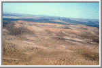
 Wolfe Creek, Australia 19°10' S, 127° 48' E; rim diameter: 0.875 kilometers (.544 miles); age: 300,000 years Wolfe Creek is a relatively well-preserved crater that is partly buried under wind blown sand. The crater is situated in the flat desert plains of north-central Australia. Its crater rim rises ~25 meters (82 feet) above the surrounding plains and the crater floor is ~50 meters (164 feet) below the rim. Oxidized remnants of iron meteoritic material as well as some impact glass have been found a Wolf Creek. This photograph is a south-looking, oblique aerial view of the crater. (Courtesy of V. L. Sharpton, LPI)
Terrestrial Impact Craters :Chicxulub, Yucatan Peninsula, Mexico
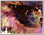
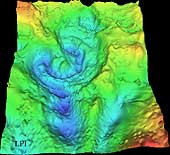 Chicxulub, Yucatan Peninsula, Mexico 21°20'N, 89°30'W; diameter: 170 km; age: 64.98 million years This three-dimensional map of local gravity and magnetic field variations shows a multiringed structure called Chicxulub named after a village located near its center. The impact basin is buried by several hundred meters of sediment, hiding it from view. This image shows the basin viewed obliquely from approximately 60° above the surface looking north, with artificial lighting from the south. The image covers 88 to 90.5° west longitude and 19.5 to 22.5° north latitude. NASA scientists believe that an asteroid 10 to 20 kilometers (6 to 12 miles) in diameter produced this impact basin. The asteroid hit a geologically unique, sulfur-rich region of the Yucatan Peninsula and kicked up billions of tons of sulfur and other materials into the atmosphere. Darkness prevailed for about half a year after the collision. This caused global temperatures to plunge near freezing. Half of the species on Earth became extinct including the dinosaurs. (Image courtesy of V. L. Sharpton, LPI)
Terrestrial Impact Craters : Barringer Meteor Crater, Arizona
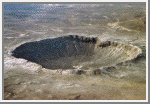 Barringer Meteor Crater, Arizona 35°02'N, 111°01'W; diameter: 1.186 kilometers (.737 miles); age: 49,000 years
The origin of this classic simple meteorite impact crater was long the subject of controversy. The discovery of fragments of the Canyon Diablo meteorite, including fragments within the breccia deposits that partially fill the structure, and a range of shock metamorphic features in the target sandstone proved its impact origin. Target rocks include Paleozoic carbonates and sandstones; these rocks have been overturned just outside the rim during ejection. The hummocky deposits just beyond the rim are remnants of the ejecta blanket. This aerial view shows the dramatic expression of the crater in the arid landscape. (Courtesy of USGS/D. Roddy and LPI)
The Tyndall Effect and Opalescene of Sky
Opalescence
The Tyndall effect is responsible for some other blue coloration's in nature: such as blue eyes, the opalescence of some gem stones, and the colour in the blue jay's wing. The colours can vary according to the size of the scattering particles. When a fluid is near its critical temperature and pressure, tiny density fluctuations are responsible for a blue coloration known as critical opalescence. People have also copied these natural effects by making ornamental glasses impregnated with particles, to give the glass a blue sheen. But not all blue colouring in nature is caused by scattering. Light under the sea is blue because water absorbs longer wavelength of light through distances over about 20 metres. When viewed from the beach, the sea is also blue because it reflects the sky, of course. Some birds and butterflies get their blue colorations by diffraction effects.
Blue Haze and Blue Moon
Clouds and dust haze appear white because they consist of particles larger than the wavelengths of light, which scatter all wavelengths equally (Mie scattering). But sometimes there might be other particles in the air that are much smaller. Some mountainous regions are famous for their blue haze. Aerosols of terpenes from the vegetation react with ozone in the atmosphere to form small particles about 200 nm across, and these particles scatter the blue light. A forest fire or volcanic eruption may occasionally fill the atmosphere with fine particles of 500-800 nm across, being the right size to scatter red light. This gives the opposite to the usual Tyndall effect, and may cause the moon to have a blue tinge since the red light has been scattered out. This is a very rare phenomenon--occurring literally once in a blue moon.
Sky in Sunset : Varity of Colour
Sunsets
When the air is clear the sunset will appear yellow, because the light from the sun has passed a long distance through air and some of the blue light has been scattered away. If the air is polluted with small particles, natural or otherwise, the sunset will be more red. Sunsets over the sea may also be orange, due to salt particles in the air, which are effective Tyndall scatterers. The sky around the sun is seen reddened, as well as the light coming directly from the sun. This is because all light is scattered relatively well through small angles--but blue light is then more likely to be scattered twice or more over the greater distances, leaving the yellow, red and orange colours.
Why Sky colour is not violet?
If shorter wavelengths are scattered most strongly, then there is a puzzle as to why the sky does not appear violet, the colour with the shortest visible wavelength. The spectrum of light emission from the sun is not constant at all wavelengths, and additionally is absorbed by the high atmosphere, so there is less violet in the light. Our eyes are also less sensitive to violet. That's part of the answer; yet a rainbow shows that there remains a significant amount of visible light coloured indigo and violet beyond the blue. The rest of the answer to this puzzle lies in the way our vision works. We have three types of colour receptors, or cones, in our retina. They are called red, blue and green because they respond most strongly to light at those wavelengths. As they are stimulated in different proportions, our visual system constructs the colours we see.
Response curves for the three types of cone in the human eye
When we look up at the sky, the red cones respond to the small amount of scattered red light, but also less strongly to orange and yellow wavelengths. The green cones respond to yellow and the more strongly-scattered green and green-blue wavelengths. The blue cones are stimulated by colours near blue wavelengths which are very strongly scattered. If there were no indigo and violet in the spectrum, the sky would appear blue with a slight green tinge. However, the most strongly scattered indigo and violet wavelengths stimulate the red cones slightly as well as the blue, which is why these colours appear blue with an added red tinge. The net effect is that the red and green cones are stimulated about equally by the light from the sky, while the blue is stimulated more strongly. This combination accounts for the pale sky blue colour. It may not be a coincidence that our vision is adjusted to see the sky as a pure hue. We have evolved to fit in with our environment; and the ability to separate natural colours most clearly is probably a survival advantage.
The Sky Colour is blue : Why ?
A clear cloudless day-time sky is blue because molecules in the air scatter blue light from the sun more than they scatter red light. When we look towards the sun at sunset, we see red and orange colours because the blue light has been scattered out and away from the line of sight.
The white light from the sun is a mixture of all colours of the rainbow. This was demonstrated by Isaac Newton, who used a prism to separate the different colours and so form a spectrum. The colours of light are distinguished by their different wavelengths. The visible part of the spectrum ranges from red light with a wavelength of about 720 nm, to violet with a wavelength of about 380 nm, with orange, yellow, green, blue and indigo between. The three different types of colour receptors in the retina of the human eye respond most strongly to red, green and blue wavelengths, giving us our colour vision.
Tyndall Effect
The first steps towards correctly explaining the colour of the sky were taken by John Tyndall in 1859. He discovered that when light passes through a clear fluid holding small particles in suspension, the shorter blue wavelengths are scattered more strongly than the red. This can be demonstrated by shining a beam of white light through a tank of water with a little milk or soap mixed in. From the side, the beam can be seen by the blue light it scatters; but the light seen directly from the end is reddened after it has passed through the tank. The scattered light can also be shown to be polarised using a filter of polarised light, just as the sky appears a deeper blue through polaroid sun glasses.
This is most correctly called the Tyndall effect, but it is more commonly known to physicists as Rayleigh scattering--after Lord Rayleigh, who studied it in more detail a few years later. He showed that the amount of light scattered is inversely proportional to the fourth power of wavelength for sufficiently small particles. It follows that blue light is scattered more than red light by a factor of (700/400)4 ~= 10.
Dust or Molecules?
Tyndall and Rayleigh thought that the blue colour of the sky must be due to small particles of dust and droplets of water vapour in the atmosphere. Even today, people sometimes incorrectly say that this is the case. Later scientists realised that if this were true, there would be more variation of sky colour with humidity or haze conditions than was actually observed, so they supposed correctly that the molecules of oxygen and nitrogen in the air are sufficient to account for the scattering. The case was finally settled by Einstein in 1911, who calculated the detailed formula for the scattering of light from molecules; and this was found to be in agreement with experiment. He was even able to use the calculation as a further verification of Avogadro's number when compared with observation. The molecules are able to scatter light because the electromagnetic field of the light waves induces electric dipole moments in the molecules.
Clouds from Space : Weather System Margin
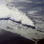
 Weather System Margin
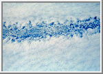
 The Discovery crew photographed this very distinct stripe running through the clouds for several hundred miles. Two weather systems are sliding past each other like crustal plates on the Earth's surface. The one at the top of the photograph (geographical north) is moving up and curing away slightly to the north, while the system at the bottom of the frame is moving westward and curving gently to the south in conjunction with a cyclone located several hundred miles away. The miniature cold-water gyres on the fringes of the two weather systems indicate that a channel of colder water runs under the break in the clouds and is reflected above where colder air runs between the two cloud masses. (Courtesy LPI/NASA. Picture #25-31-011)
Clouds from Space : Eye of Typhoon Yuri
 Eye of Typhoon Yuri
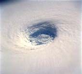
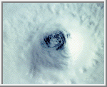
 This spectacular, low-oblique photograph shows the bowl-shaped eye (center of photograph) of Typhoon Yuri in the western Pacific Ocean just west of the Northern Mariana Islands. The eye wall descends almost to the sea surface, a distance of nearly 45,000 feet (13,800 meters). In this case the eye is filled with clouds, but in many cases the sea surface can be seen through the eye. Yuri grew to super typhoon status, packing maximum sustained winds estimated at 165 miles (270 kilometers) per hour, with gusts reaching an estimated 200 miles (320 kilometers) per hour. The storm moved west toward the Philippine Islands before turning northeast into the north Pacific Ocean, thus avoiding any major landmass. (Courtesy NASA)
Clouds from Space : Vortex Street Near Madeira Island
 Vortex Street Near Madeira Island
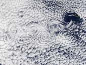
 A vortex street streams slightly southeast of the Ilha da Madeira (Madeira Island) in this true-color Terra MODIS image acquired December 1, 2002. A vortex street forms when clouds over the ocean are disturbed by winds passing over land or other above-sea-surface obstacles, in this case the Ilha da Madeira. The southeastern movement of the low-level winds caused the clouds to line up in the same direction, called a street, and the wind's passage over the islands caused the swirls, called vortices. The particular kind of clouds forming the vortex street is referred to as "closed cell". These cells, or parcels of air, often occur in roughly hexagonal arrays in a layer of air that behaves like a fluid (as often occurs in the atmosphere) and begins to convect due to heating at the base or cooling at the top. In these closed cell clouds, warm air is rising at their centers and sinking around the edges to create this honeycomb-like pattern. (Courtesy GSFC/NASA)
Clouds from Space : Typhoon Odessa
 Typhoon Odessa
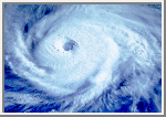
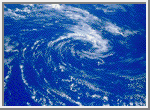
 Odessa is one of the strongest circular storm patterns seen by shuttle crews to date and has a superb tightly formed eye. The tighter the eye in a circular storm, the stronger the winds underneath. Mission STS 51-1 came to be known as the mission of all the hurricanes, tracking no less than four circular storms around the globe. Live pictures from Discovery of Hurricane Elena in the Gulf of Mexico were transmitted directly from Mission Control in Houston to the National Hurricane Center in Florida for correlation with conventional weather satellite and high level aircraft data. (Courtesy LPI/NASA. Picture #27-35-077)
Clouds from Space : Eye of Hurricane Kamysi
 Eye of Hurricane Kamysi
 During the Solar Maximum Satellite Repair Mission, astronauts had an excellent opportunity to look down the eye of Hurricane Kamysi over the Indian Ocean. Clear blue water can be seen through the hurricane's eye, and the crew reported that they could see the ocean wave below. Unfortunately, the camera film could not pick them out. (Courtesy LPI/NASA. Picture #13-35-1499)
Clouds from Space : Anticyclonic Clouds
 Anticyclonic Clouds
 This pinwheel of anticyclonic clouds was photographed by the STS 41-B crew over the southern hemisphere of the Pacific Ocean. The ground winds at the center of this cyclonic system reach 80 kilometers per hour (50 miles an hour). Circular storms in the northern hemisphere produce spiraling clouds with a clockwise pattern, while southern latitude storms have a counterclockwise cloud motion. (Courtesy LPI/NASA. Picture #11-45-2834)
Clouds from Space : Open Cells Over The Ocean
 Open Cells Over The Ocean
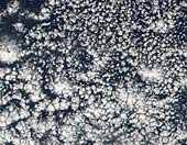
 What atmospheric scientists refer to as open cell cloud formation is a regular occurrence on the back side of a low pressure system or cyclone in the mid-latitudes. In the northern hemisphere, a low-pressure system will draw in surrounding air and spin it counterclockwise. That means that on the back side of the low pressure center, cold air will be drawn in from the north, and on the front side, warm air will be drawn up from latitudes closer to the equator. This movement of an air mass is called advection, and when cold air advection occurs over warmer waters, open cell cloud formations often result.
This image shows open cell cloud formation over the Atlantic Ocean off the southeast coast of the United States. This particular formation is the result of a low-pressure system sitting out in the North Atlantic Ocean a few hundred miles east of Massachusetts. Cold air is being drawn down from the north on the western side of the low and the open cell cumulus clouds begin to form as the cold air passes over the warmer Caribbean waters. (Courtesy NASA/GSFC)
This image shows open cell cloud formation over the Atlantic Ocean off the southeast coast of the United States. This particular formation is the result of a low-pressure system sitting out in the North Atlantic Ocean a few hundred miles east of Massachusetts. Cold air is being drawn down from the north on the western side of the low and the open cell cumulus clouds begin to form as the cold air passes over the warmer Caribbean waters. (Courtesy NASA/GSFC)
Clouds from Space: Cloud Tail, Lake Tana
 Cloud Tail, Lake Tana
 Islands or high land, elevated above the surroundings and interrupting the air stream, can produce "tails" as well as "wakes." Shuttle astronauts have frequently observed Dek Island in Lake Tana in Ethiopia, the source of the Blue Nile, with a well-developed cloud tail. This occurs when the land mass disrupts the air flow, creating downwind turbulence that promotes condensation. The lake stands at 1,800 meters (6,000 feet) above sea level. (Courtesy LPI/NASA. Picture #27-38-003)
Clouds from Space: Island Wake, Hawaii
 Island Wake, Hawaii
 The combination of warm water temperature and hundreds of square miles of ocean, uninterrupted by land masses, results in a regular cumulus and stratocumulus cloud formation. In the Pacific Ocean the Trade Winds propel the clouds from east to west across the ocean. When the air current is intercepted by a sufficiently high land mass, such as the Big Island of Hawaii, the stable cloud pattern is interrupted and the clouds divide to bypass the island in a wide arc forming an "island wake." In addition to illustrating how gracefully the clouds circumnavigate Hawaii's volcanic peaks, the photograph shows how the prevailing wind direction dictates that the north and northeast of the island are wetter than the western side of the island and frequently under cloud. The clouds deposit rain on the low ground before dividing and spinning out to sea when they meet the Kohala Mountains and Mauna Kea with its summit at 4,205 meters (13,796 feet). (Courtesy LPI/NASA. Picture #25-47-016)
Clouds from Space: Cloud Streets, Tiladumati Atoll, Maldive Islands
 Cloud Streets, Tiladumati Atoll, Maldive Islands
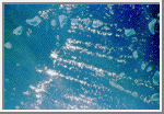
 Small cumulus clouds frequently form in parallel rows or "cloud streets" in stable air conditions. These cloud streets over the reefs of the Maldive Islands in the Indian Ocean denote the prevailing wind direction, the cloud streets lying parallel with the wind. Turbulent air lifted by the windward portions of the islands promotes cloud formation downwind. (Courtesy LPI/NASA. Picture #13-35-1459)
Clouds from Space: Jet Stream Convergence
 Jet Stream Convergence
This photograph taken over Namibia reveals another effect of jet streams. Here two streams converge; cloud has formed in the corridor between the two streams. Turbulence along the margins of the jet stream may explain the sharp boundary. The point of convergence of the two air streams is precisely located by this photograph. Shadows mark the cloud edges against a sunlit Namibian backdrop. (Courtesy LPI/NASA. Picture #13-31-092)
Clouds from Space: Jet Stream Cirrus, Saudi Arabia
 Jet Stream Cirrus, Saudi Arabia
 This series of cirrus clouds is know as "roll clouds" because they are sculpted into tight rolls by air currents from the jet stream over Saudi Arabia and the Red Sea. The crest-to-crest spacing of the cloud bands can be used to calculate the velocity of the jet stream. (Courtesy LPI/NASA. Picture #13-32-1159)
Clouds from Space: Unique Cloud Lanes, Oman
 Unique Cloud Lanes, Oman
 These wispy rows of cloud or "cloud lanes" are recognized as a "landmark" by successive shuttle crews. This unique cloud formation off Oman is virtually constant at certain times of year. The clouds are created by a small vortex in the low level wind current. There is little difference between the ocean and atmosphere temperatures here, but the air current may have been subjected to heating from the Somali Current. (Courtesy LPI/NASA. Picture #2-10-649)
Clouds from Space: Coastal Current, Namibia
 Coastal Current, Namibia
 Condensing moisture from ocean currents in some parts of the world creates clouds that stay uniformly in position above that current for months at a time. This example shows clouds hanging above the cold Benguela current, which travels northward along the Atlantic coast of southwestern Africa. It is interesting that while the ocean is densely cloud-covered and the clouds lap at the coast, they never cross the coastline. The pinkish-colored Namib Desert is one of the driest places on Earth, confirming that the cloud associated with the ocean current does not stry off its prescribed track. Indeed the Namib Desert is home to unique inhabitants - insects with leg hairs especially adapted to collect moisture from morning dew - a strange irony of life on Earth where moisture-laden clouds hang so close by. (Courtesy LPI/NASA. Picture #25-46-076)
Clouds from Space: Cloud Margin, Bering Sea
 Cloud Margin, Bering Sea
 All that can be seen in this photograph is cloud stretching several hundred kilometers to the limb of the Earth, yet it tells us a great deal about the water in the Bering Sea below. The line or cloud margin running diagonally across the frame with dense, thick cloud to the right and lighter, more broken cloud to the left reflects an ocean current margin. A difference in water temperature on either side of the margin is reflected in the cloud forms condensing above. This striking cloud boundary stretches for 800-960 kilometers (500-600 miles) in this photograph. (Courtesy LPI/NASA. Picture #17-41-058)
Clouds from Space: Cumulus Cloud Tops
 Cumulus Cloud Tops
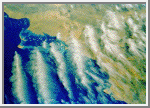
 This oblique photograph, acquired in February 1984 by an astronaut aboard the space shuttle, shows a series of mature thunderstorms located near the Parana River in southern Brazil. With abundant warm temperatures and moisture-laden air in this part of Brazil, large thunderstorms are commonplace. A number of overshooting tops and anvil clouds are visible at the tops of the clouds. When the rising cumulus columns meet the tropopause, or base of the stratosphere, at about 15,000 kilometers (50,000 feet), they reach a ceiling and can no longer rise buoyantly by convection. The stable temperature of the stratosphere suppresses further adiabatic ascent of moisture that has been driven through the troposphere by the 5-6.8 degree/kilometer (8-11 degree/mile) lapse rate. Instead, ice clouds spread horizontally into the extended cirrus heads seen in this photograph, forming the "anvil heads" that we identify from the ground. The finer, feathery development around the edges of some of the thunderheads is glaciation - water vapor in the cloud is turning to ice at high altitude. Storms of this magnitude can drop large amounts of rainfall in a short period of time, causing flash floods. (Courtesy NASA-JSC)
Clouds from Space: Thunderstorms, Brazil
 Thunderstorms, Brazil
 These cumulus thunderheads near São Paulo, Brazil, where photographed from almost directly overhead by the STS 41-B crew. This perspective conveys something of the energy that drives these cloud columns to punch up into the atmosphere. The foreshortening resulting from the near-vertical viewing angle disguises the fact that the cloudheads so prominently in view are but the tops of massive thunderhead storm clouds that can tower up to 18,000 meters (60,000 feet) in the tropics. (Courtesy LPI/NASA. Picture #11-41-2343)
Clouds from Space: Florida Squall Line
 Florida Squall Line
 This spectacular, low-oblique photograph shows a convective line of thunderstorms associated with a passing cold front over Florida. A shadow from the height of the thunderstorms, caused by early morning sunlight, can be seen traversing the scene southwest to northeast. The clouds in the storm system rise to about 16,500 meters (55,000 feet). The V-shaped cloud structure is normally associated with cold fronts that cross the Gulf of Mexico and Florida in late winter and early spring. Severe thunderstorms and tornadoes usually occur with this type of storm system. At the time this photograph was taken, weather stations across Florida reported severe thunderstorms, strong winds, hail, torrential rains, and numerous tornadoes. (Courtesy NASA)
Clouds from Space: Jet Stream
 Jet Stream
 The Northern Hemisphere Jet Stream can be seen crossing Cape Breton Island in the Maritime Provinces of Eastern Canada. The Jet Stream is a narrow zone of high-speed winds typically found at altitudes of 4 to 8 miles (8-12 km) above the earth. They result from temperature contrasts between polar and tropical regions. The strongest Jet Stream winds are found in the winter when the contrast between polar and tropical regions is the greatest. Wind speeds can reach 90 to over 180 miles per hour (145 to over 290 km/h) from west to east. Jet Streams are found between latitudes 20? to near 55? north and south. During the winter months over the United States and southern Canada, the path taken by the Jet Stream can have a large influence on the weather conditions of this region. (Courtesy NASA)
Earth : Our Planet
Earth is the third planet from the Sun and the fifth largest:
        orbit:    149,600,000 km (1.00 AU) from Sun
      diameter: 12,756.3 km
      mass:     5.972e24 kg
Amazing pictures of Earth from space combine useful science and artistic beauty.
Orbit : Nasa Astronauts Photograph the Earth
A beautiful coffee table book. Kids often ask me which is my favorite planet. My answer is always "Earth". This book shows why.
Earth is the only planet whose English name does not derive from Greek/Roman mythology. The name derives from Old English and Germanic. There are, of course, hundreds of other names for the planet in other languages. In Roman Mythology, the goddess of the Earth was Tellus - the fertile soil (Greek: Gaia, terra mater - Mother Earth).
It was not until the time of Copernicus (the sixteenth century) that it was understood that the Earth is just another planet.
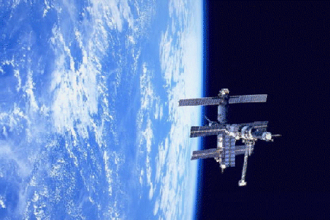
Mir space station and Earth's limb
Earth, of course, can be studied without the aid of spacecraft. Nevertheless it was not until the twentieth century that we had maps of the entire planet. Pictures of the planet taken from space are of considerable importance; for example, they are an enormous help in weather prediction and especially in tracking and predicting hurricanes. And they are extraordinarily beautiful.
The Earth is divided into several layers which have distinct chemical and seismic properties (depths in km):
0- 40 CrustThe crust varies considerably in thickness, it is thinner under the oceans, thicker under the continents. The inner core and crust are solid; the outer core and mantle layers are plastic or semi-fluid. The various layers are separated by discontinuities which are evident in seismic data; the best known of these is the Mohorovicic discontinuity between the crust and upper mantle.
40- 400 Upper mantle
400- 650 Transition region
650-2700 Lower mantle
2700-2890 D'' layer
2890-5150 Outer core
5150-6378 Inner core
Most of the mass of the Earth is in the mantle, most of the rest in the core; the part we inhabit is a tiny fraction of the whole (values below x10^24 kilograms):
      atmosphere     = 0.0000051
     oceans         = 0.0014
     crust          = 0.026
     mantle         = 4.043
     outer core     = 1.835
     inner core     = 0.09675
The core is probably composed mostly of iron (or nickel/iron) though it is possible that some lighter elements may be present, too. Temperatures at the center of the core may be as high as 7500 K, hotter than the surface of the Sun. The lower mantle is probably mostly silicon, magnesium and oxygen with some iron, calcium and aluminum. The upper mantle is mostly olivene and pyroxene (iron/magnesium silicates), calcium and aluminum. We know most of this only from seismic techniques; samples from the upper mantle arrive at the surface as lava from volcanoes but the majority of the Earth is inaccessible. The crust is primarily quartz (silicon dioxide) and other silicates like feldspar. Taken as a whole, the Earth's chemical composition (by mass) is:
 South America by Galileo
 The Earth is the densest major body in the solar system.
The other terrestrial planets probably have similar structures and compositions with some differences: the Moon has at most a small core; Mercury has an extra large core (relative to its diameter); the mantles of Mars and the Moon are much thicker; the Moon and Mercury may not have chemically distinct crusts; Earth may be the only one with distinct inner and outer cores. Note, however, that our knowledge of planetary interiors is mostly theoretical even for the Earth.
Unlike the other terrestrial planets, Earth's crust is divided into several separate solid plates which float around independently on top of the hot mantle below. The theory that describes this is known as plate tectonics. It is characterized by two major processes: spreading and subduction. Spreading occurs when two plates move away from each other and new crust is created by upwelling magma from below. Subduction occurs when two plates collide and the edge of one dives beneath the other and ends up being destroyed in the mantle. There is also transverse motion at some plate boundaries (i.e. the San Andreas Fault in California) and collisions between continental plates (i.e. India/Eurasia). There are (at present) eight major plates:
- North American Plate - North America, western North Atlantic and Greenland
 Earth's Plate Boundaries delineated by earthquake epicenters
 - South American Plate - South America and western South Atlantic
- Antarctic Plate - Antarctica and the "Southern Ocean"
- Eurasian Plate - eastern North Atlantic, Europe and Asia except for India
- African Plate - Africa, eastern South Atlantic and western Indian Ocean
- Indian-Australian Plate - India, Australia, New Zealand and most of Indian Ocean
- Nazca Plate - eastern Pacific Ocean adjacent to South America
- Pacific Plate - most of the Pacific Ocean (and the southern coast of California!)
There are also twenty or more small plates such as the Arabian, Cocos, and Philippine Plates. Earthquakes are much more common at the plate boundaries. Plotting their locations makes it easy to see the plate boundaries.
The Earth's surface is very young. In the relatively short (by astronomical standards) period of 500,000,000 years or so erosion and tectonic processes destroy and recreate most of the Earth's surface and thereby eliminate almost all traces of earlier geologic surface history (such as impact craters). Thus the very early history of the Earth has mostly been erased. The Earth is 4.5 to 4.6 billion years old, but the oldest known rocks are about 4 billion years old and rocks older than 3 billion years are rare. The oldest fossils of living organisms are less than 3.9 billion years old. There is no record of the critical period when life was first getting started.
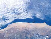
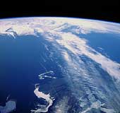
 Space Shuttle view of the Strait of Gibraltar
 71 Percent of the Earth's surface is covered with water. Earth is the only planet on which water can exist in liquid form on the surface (though there may be liquid ethane or methane on Titan's surface and liquid water beneath the surface of Europa). Liquid water is, of course, essential for life as we know it. The heat capacity of the oceans is also very important in keeping the Earth's temperature relatively stable. Liquid water is also responsible for most of the erosion and weathering of the Earth's continents, a process unique in the solar system today (though it may have occurred on Mars in the past).
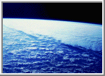
 Earth's atmosphere seen at the limb
 The Earth's atmosphere is 77% nitrogen, 21% oxygen, with traces of argon, carbon dioxide and water. There was probably a very much larger amount of carbon dioxide in the Earth's atmosphere when the Earth was first formed, but it has since been almost all incorporated into carbonate rocks and to a lesser extent dissolved into the oceans and consumed by living plants. Plate tectonics and biological processes now maintain a continual flow of carbon dioxide from the atmosphere to these various "sinks" and back again. The tiny amount of carbon dioxide resident in the atmosphere at any time is extremely important to the maintenance of the Earth's surface temperature via the greenhouse effect. The greenhouse effect raises the average surface temperature about 35 degrees C above what it would otherwise be (from a frigid -21 C to a comfortable +14 C); without it the oceans would freeze and life as we know it would be impossible. (Water vapor is also an important greenhouse gas.)
 View from Apollo 11
 The presence of free oxygen is quite remarkable from a chemical point of view. Oxygen is a very reactive gas and under "normal" circumstances would quickly combine with other elements. The oxygen in Earth's atmosphere is produced and maintained by biological processes. Without life there would be no free oxygen.
The interaction of the Earth and the Moon slows the Earth's rotation by about 2 milliseconds per century. Current research indicates that about 900 million years ago there were 481 18-hour days in a year.
Earth has a modest magnetic field produced by electric currents in the outer core. The interaction of the solar wind, the Earth's magnetic field and the Earth's upper atmosphere causes the auroras (see the Interplanetary Medium). Irregularities in these factors cause the magnetic poles to move and even reverse relative to the surface; the geomagnetic north pole is currently located in northern Canada. (The "geomagnetic north pole" is the position on the Earth's surface directly above the south pole of the Earth's field; see this diagram.)
The Earth's magnetic field and its interaction with the solar wind also produce the Van Allen radiation belts, a pair of doughnut shaped rings of ionized gas (or plasma) trapped in orbit around the Earth. The outer belt stretches from 19,000 km in altitude to 41,000 km; the inner belt lies between 13,000 km and 7,600 km in altitude.
GANGA BANDHAN : SAVE GANGES RIVER
I GOT THIS PDF FROM NET. It's stating the miserable situation of GANGES RIVER. THE PDF FILE includes information, image and analysis by experts. I am giving this here for sharing with other -
GANGA BANDHAN
Click above link to get PDF File and share it with others
Click above link to get PDF File and share it with others
Green Glossary: Keystone Species

A keystone species is a species "so critical to an ecosystem that its removal could potentially destroy the entire system...It is important to consider keystone species when making any decisions that could affect the natural environment. A small impact on keystone species could cause major disruption for the whole ecosystem."
Within the prairie ecosystem, the black-tailed prairie dog is a keystone species. "More than 200 other wildlife species have been observed on or near prairie dog colonies," explains PrairieDogs.org. "Some of these animals depend on prairie dogs as a food source or for their habitat. Among those animals associated with prairie dogs and their colonies are bald and golden eagles, swift foxes, coyotes, ferruginous hawks, burrowing owls, badgers and black-footed ferrets. Countless insects and some plants are also associated with prairie dog towns. Countless plants and invertebrate species also rely heavily on prairie dogs and their activities."
As a keystone species, black-tailed prairie dogs impact the prairie ecosystem in multiple ways:
- Their burrows act as homes to other creatures, including burrowing owls, badgers, rabbits, black-footed ferrets, snakes, salamanders, and insects.
- Their burrowing activity works to loosen and churn up the soil, increasing its ability to sustain plant life.
- Their foraging and feeding practices enable a more nutritious, diverse and nitrogen-rich mixture of grasses and forbs (broad-leafed vegetation) to grow.
- The enriched vegetation attracts an amazing array of wildlife who graze in their colonies.
- Black-tailed prairie dogs play an integral role in the prairie food chain; they are a critical food source for such animals as the endangered black-footed ferret, swift fox, coyotes, hawks, eagles and badgers.
Subscribe to:
Posts (Atom)