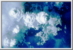
A clear cloudless day-time sky is blue because molecules in the air scatter blue light from the sun more than they scatter red light. When we look towards the sun at sunset, we see red and orange colours because the blue light has been scattered out and away from the line of sight.
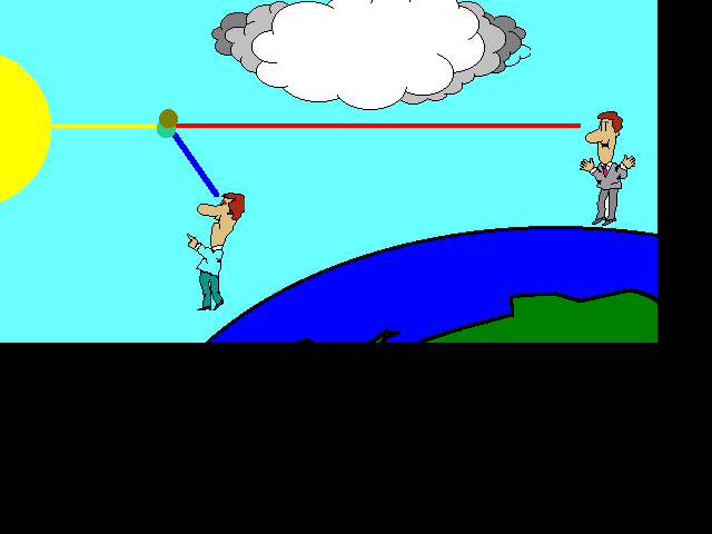
The white light from the sun is a mixture of all colours of the rainbow. This was demonstrated by Isaac Newton, who used a prism to separate the different colours and so form a spectrum. The colours of light are distinguished by their different wavelengths. The visible part of the spectrum ranges from red light with a wavelength of about 720 nm, to violet with a wavelength of about 380 nm, with orange, yellow, green, blue and indigo between. The three different types of colour receptors in the retina of the human eye respond most strongly to red, green and blue wavelengths, giving us our colour vision.
Tyndall Effect
The first steps towards correctly explaining the colour of the sky were taken by John Tyndall in 1859. He discovered that when light passes through a clear fluid holding small particles in suspension, the shorter blue wavelengths are scattered more strongly than the red. This can be demonstrated by shining a beam of white light through a tank of water with a little milk or soap mixed in. From the side, the beam can be seen by the blue light it scatters; but the light seen directly from the end is reddened after it has passed through the tank. The scattered light can also be shown to be polarised using a filter of polarised light, just as the sky appears a deeper blue through polaroid sun glasses.
This is most correctly called the Tyndall effect, but it is more commonly known to physicists as Rayleigh scattering--after Lord Rayleigh, who studied it in more detail a few years later. He showed that the amount of light scattered is inversely proportional to the fourth power of wavelength for sufficiently small particles. It follows that blue light is scattered more than red light by a factor of (700/400)4 ~= 10.
Dust or Molecules?
Tyndall and Rayleigh thought that the blue colour of the sky must be due to small particles of dust and droplets of water vapour in the atmosphere. Even today, people sometimes incorrectly say that this is the case. Later scientists realised that if this were true, there would be more variation of sky colour with humidity or haze conditions than was actually observed, so they supposed correctly that the molecules of oxygen and nitrogen in the air are sufficient to account for the scattering. The case was finally settled by Einstein in 1911, who calculated the detailed formula for the scattering of light from molecules; and this was found to be in agreement with experiment. He was even able to use the calculation as a further verification of Avogadro's number when compared with observation. The molecules are able to scatter light because the electromagnetic field of the light waves induces electric dipole moments in the molecules.


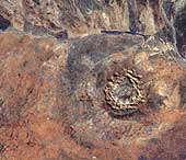
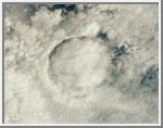
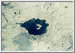
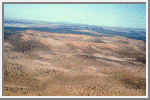
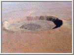
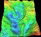
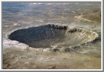
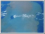
 23°50'S, 132°19'E; rim diameter: 24 kilometers; age: 142.5 +- 0.5 million years 142 million years ago, an asteroid or comet slammed into what is now the Missionary Plains in Australia's Northern Territory, forming a crater 24 kilometers in diameter and 5 kilometers deep. Today, like a bull's eye, the circular ring of hills that defines Gosses Bluff stands as a stark reminder of the event. The crater is located just south of MacDonnel Ranges (top of the picture). It is highly eroded. The circular ring of hills (5 kilometers or 3 miles diameter) is actually the results from differential erosion of the central uplift within this large complex crater. The crater rim is eroded to the point that it is no longer visible though it is probably located along the grayish colored drainage system outside the inner ring. (Courtesy USGS)
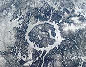
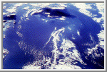