 Chicxulub, Yucatan Peninsula, Mexico
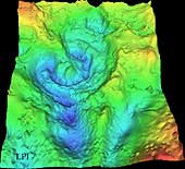
21°20'N, 89°30'W; diameter: 170 km; age: 64.98 million years This three-dimensional map of local gravity and magnetic field variations shows a multiringed structure called Chicxulub named after a village located near its center. The impact basin is buried by several hundred meters of sediment, hiding it from view. This image shows the basin viewed obliquely from approximately 60° above the surface looking north, with artificial lighting from the south. The image covers 88 to 90.5° west longitude and 19.5 to 22.5° north latitude. NASA scientists believe that an asteroid 10 to 20 kilometers (6 to 12 miles) in diameter produced this impact basin. The asteroid hit a geologically unique, sulfur-rich region of the Yucatan Peninsula and kicked up billions of tons of sulfur and other materials into the atmosphere. Darkness prevailed for about half a year after the collision. This caused global temperatures to plunge near freezing. Half of the species on Earth became extinct including the dinosaurs.
(Image courtesy of V. L. Sharpton, LPI)

No comments:
Post a Comment