
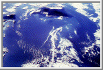
 Island Wake, Hawaii
 The combination of warm water temperature and hundreds of square miles of ocean, uninterrupted by land masses, results in a regular cumulus and stratocumulus cloud formation. In the Pacific Ocean the Trade Winds propel the clouds from east to west across the ocean. When the air current is intercepted by a sufficiently high land mass, such as the Big Island of Hawaii, the stable cloud pattern is interrupted and the clouds divide to bypass the island in a wide arc forming an "island wake." In addition to illustrating how gracefully the clouds circumnavigate Hawaii's volcanic peaks, the photograph shows how the prevailing wind direction dictates that the north and northeast of the island are wetter than the western side of the island and frequently under cloud. The clouds deposit rain on the low ground before dividing and spinning out to sea when they meet the Kohala Mountains and Mauna Kea with its summit at 4,205 meters (13,796 feet). (Courtesy LPI/NASA. Picture #25-47-016)
No comments:
Post a Comment