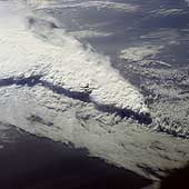
 Florida Squall Line
 This spectacular, low-oblique photograph shows a convective line of thunderstorms associated with a passing cold front over Florida. A shadow from the height of the thunderstorms, caused by early morning sunlight, can be seen traversing the scene southwest to northeast. The clouds in the storm system rise to about 16,500 meters (55,000 feet). The V-shaped cloud structure is normally associated with cold fronts that cross the Gulf of Mexico and Florida in late winter and early spring. Severe thunderstorms and tornadoes usually occur with this type of storm system. At the time this photograph was taken, weather stations across Florida reported severe thunderstorms, strong winds, hail, torrential rains, and numerous tornadoes. (Courtesy NASA)

No comments:
Post a Comment