
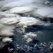
 Cumulus Cloud Tops
 This oblique photograph, acquired in February 1984 by an astronaut aboard the space shuttle, shows a series of mature thunderstorms located near the Parana River in southern Brazil. With abundant warm temperatures and moisture-laden air in this part of Brazil, large thunderstorms are commonplace. A number of overshooting tops and anvil clouds are visible at the tops of the clouds. When the rising cumulus columns meet the tropopause, or base of the stratosphere, at about 15,000 kilometers (50,000 feet), they reach a ceiling and can no longer rise buoyantly by convection. The stable temperature of the stratosphere suppresses further adiabatic ascent of moisture that has been driven through the troposphere by the 5-6.8 degree/kilometer (8-11 degree/mile) lapse rate. Instead, ice clouds spread horizontally into the extended cirrus heads seen in this photograph, forming the "anvil heads" that we identify from the ground. The finer, feathery development around the edges of some of the thunderheads is glaciation - water vapor in the cloud is turning to ice at high altitude. Storms of this magnitude can drop large amounts of rainfall in a short period of time, causing flash floods. (Courtesy NASA-JSC)
No comments:
Post a Comment